




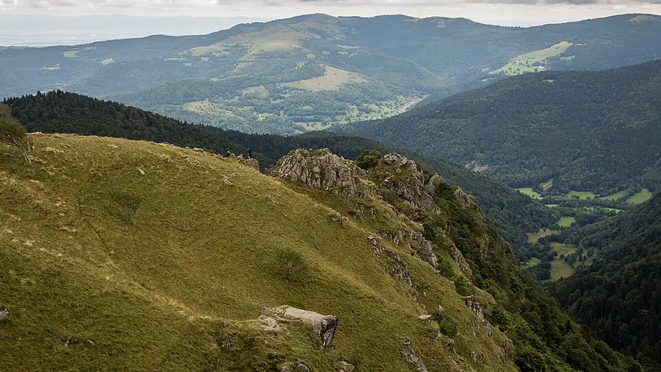
 Photo: Nicolas Torquet · CC BY-SA 3.0 · Wikimedia Commons
Trail Running
Light on Trail Pierre-Percée
 Celles-sur-Plaine, France
April 4, 2027Date confirmed
54 km37 km17 km
Lakes & PondsNature & Off-Road+2
FRTrail Running · Vosges · 22 Events · 88 Races
22 verified events with 88 individual races (2 confirmed dates) in Vosges complete with route maps and elevation profiles.
Selected Events
Photo: Nicolas Torquet · CC BY-SA 3.0 · Wikimedia CommonsCelles-sur-Plaine, France
April 4, 2027Date confirmed
Photo: Nicolas Torquet · CC BY-SA 3.0 · Wikimedia CommonsGérardmer, France
Date to be announcedDate TBA
Photo: Nicolas Torquet · CC BY-SA 3.0 · Wikimedia CommonsLe Thillot, France
Date to be announcedDate TBA
Photo: Nicolas Torquet · CC BY-SA 3.0 · Wikimedia CommonsÉpinal, France
Date to be announcedDate TBA
 Photo: Jonathan Beech · CC BY-SA 4.0 · Wikimedia Commons
Chantraine, France
Date to be announcedDate TBA
Photo: Nicolas Torquet · CC BY-SA 3.0 · Wikimedia CommonsMortagne, France
Date to be announcedDate TBA
Photo: Nicolas Torquet · CC BY-SA 3.0 · Wikimedia CommonsXonrupt-Longemer, France
Date to be announcedDate TBA
Photo: Nicolas Torquet · CC BY-SA 3.0 · Wikimedia CommonsLaval-sur-Vologne, France
Date to be announcedDate TBA
Dates & Schedule
| Date | Event | Location | Disciplines | Distances |
|---|---|---|---|---|
| Apr 4, 2027 | Light on Trail Pierre-Percée | Celles-sur-Plaine, Grand Est, FR | Trail Running | 54 km37 km17 km |
| Date | Event | Location | Disciplines | Distances |
|---|---|---|---|---|
| Date to be announced | Trail de la Vallée des Lacs | Gérardmer, Grand Est, FR | Trail Running | 65 km33 km15 km13 km |
| Date to be announced | Trail des Hautes Mynes du Thillot | Le Thillot, Grand Est, FR | Trail RunningNordic Walking | 28 km14 km6 km2 km |
| Date to be announced | Trail des Terroirs Vosgiens | Épinal, Grand Est, FR | Trail RunningWalking & Hiking | 21 km14 km11 km8 km |
| Date to be announced | Trail des Brosses | Chantraine, Grand Est, FR | Trail Running | 35 km22 km10 km6 km |
| Date to be announced | Rush du bout du monde | Mortagne, Grand Est, FR | Trail RunningWalking & Hiking | 24 km14 km10 km5 km |
| Date to be announced | Course des 4 Massifs | Xonrupt-Longemer, Grand Est, FR | Trail Running | 23 km22 km20 km18 km |
| Date to be announced | Trail de l'avison | Laval-sur-Vologne, Grand Est, FR | Trail RunningWalking & Hiking | 14 km7 km3 km |
| Date to be announced | Virine Trail Tour | Bouxières-aux-Bois, Grand Est, FR | Trail RunningWalking & Hiking | 17 km10 km |
| Date to be announced | Trail blanc des Vosges | Saint-Maurice-sur-Moselle, Grand Est, FR | Trail Running | 18 km7 km5 km |
| Date to be announced | Trail des Callunes | Ban-de-Sapt, Grand Est, FR | Trail Running | 33 km26 km12 km |
| Date to be announced | Trail Hivernal de la Moselotte Thm | Cornimont, Grand Est, FR | Trail Running | 38 km28 km14 km |
Overview & Route Character
Off-road running on singletrack, forest paths, and alpine ridges, spanning short discovery trails to high-mountain ultra-trails. Trail running is defined by elevation gain, technical terrain, and natural landscapes across forest singletrack, coastal cliffs, and mountain passes. In this Trail Running in Vosges directory, RunningCompass curates 22 events comprising 88 individual races, including 2 events with confirmed upcoming dates.
Courses span distances ranging from 2 km to 65 km and elevation gains up to +3,500 m. Key host locations include Celles-sur-Plaine, Gérardmer, Le Thillot, Épinal. Notable events in this selection include Light on Trail Pierre-Percée, Trail de la Vallée des Lacs, Trail des Hautes Mynes du Thillot.
This overview currently includes 22 verified events featuring 88 individual races. Of these, 2 events have confirmed upcoming dates on the calendar, while 20 events await next edition date confirmation from the organizer.
Races in this selection span distances of 2 km to 65 km. The most demanding courses reach up to +3,500 m of positive elevation gain. Featured disciplines include Trail Running, Walking & Hiking, Nordic Walking.
Top host locations include Celles-sur-Plaine, Gérardmer, Le Thillot, Épinal, Chantraine. Representative events in the catalog include Light on Trail Pierre-Percée, Trail de la Vallée des Lacs, Trail des Hautes Mynes du Thillot, Trail des Terroirs Vosgiens. Off-road running on singletrack, forest paths, and alpine ridges, spanning short discovery trails to high-mountain ultra-trails.
Every event profile provides an interactive route map, a detailed elevation chart across all 88 races, and a GPX track download. You can also switch directly to the interactive map explorer to filter by date range and distance.